- Created: August 28, 2012 10:33 am
- Updated: December 12, 2017 11:01 am
- Distance Instructions
- Distance 47 km
- Time 0 s
- Speed 0.0 km/h
- Min altitude 4 m
- Peak 88 m
- Climb 145 m
- Descent 144 m
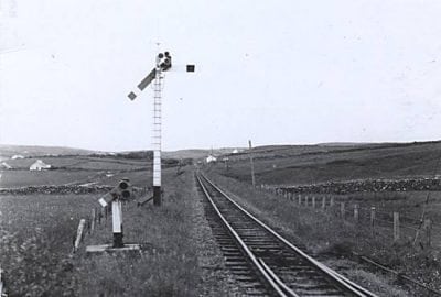
The narrow gauge West Clare Railway (WCR) was opened fully 1887 and served Ennis, Corofin, Ennistymon, Lahinch and Miltown Malbay and operated until 31 January 1961. An extension to this line, the South Clare Railway, was opened fully in 1892 and served Quilty, Kilmurry, Doonbeg and Moyasta Junction. At Moyasta the line divided into two branches. One ran west to Kilkee and the other to Kilrush and Cappagh Pier. This section of dismantled and disused railway has the potential to be developed as a walking and cycling route.
Use our Map of Ireland and Sat Nav tool to get directions and our detailed maps and GPS on our ActiveME App to find and follow the railway line live on screen and keep on track.
Gallery
The narrow gauge West Clare Railway (WCR) was opened fully 1887 and served Ennis, Corofin, Ennistymon, Lahinch and Miltown Malbay and operated until 31 January 1961. An extension to this line, the South Clare Railway, was opened fully in 1892 and served Quilty, Kilmurry, Doonbeg and Moyasta Junction. At Moyasta the line divided into two branches. One ran west to Kilkee and the other to Kilrush and Cappagh Pier. This section of dismantled and disused railway has the potential to be developed as a walking and cycling route.
Use our Map of Ireland and Sat Nav tool to get directions and our detailed maps and GPS on our ActiveME App to find and follow the railway line live on screen and keep on track.


