- Created: August 28, 2012 10:32 am
- Updated: December 12, 2017 11:02 am
- Distance Instructions
- Distance 33 km
- Time 0 s
- Speed 0.0 km/h
- Min altitude 4 m
- Peak 270 m
- Climb 392 m
- Descent 263 m
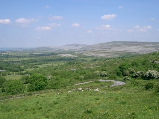
Part 4 of the Burren Way from Ballyvaughan to Carran is extremely rewarding and scenic but is a long and strenuous 7 hour (23.5km) walk. The walking route, mainly along some quiet country roads is from the picturesque village of Ballyvaughan over the unique Burren landscape and onto the village of Carran, county Clare in the west of Ireland. The Burren Way is a long distance walking route in north County Clare, Ireland and emcompasses the famous Burren landscape. At 115km (71 miles) long it is one of the longest and spectacular of Irelands National Waymarked Trails, begining in Lahinch and ending in Corofin. It crosses The Burren, one of the largest karst limestone landscapes in Europe. The Burren Way takes 5 to 8 days to complete, crossing varied and spectacular terrain on mostly quiet back roads. Typically the entire route is broken down into 5 to 6 key stages of approximate equal length or duration. You can also brake some of these longer stages into smallers part to allow everyone irrespective of fitness or time available to experience one of the best and varied walks in Ireland. The walking route officially begins in Lahinch on the Western side of Clare but you can join at various points along its length. From Lahinch, it passes through the Burren to Doolin on the coast and then incland to Lisdoonvarna and Ballyvaughan to the north. From here it goes south through the heartland of the Burren through the villages of Carran, and finishing in Corrofin on the eastern side of the Burren. The Burren way also includes some of the Mid Clare Way walking route, East Burren Loop and short walking links to Lisdoonvarna and Ballyvaughan. You also search for many other walks in the area. Use our Map of Ireland and Sat Nav tool to get directions to the start point of this walk and use our detailed map and GPS on our ActiveME App to find and follow the walking route and keep on track.
Gallery
Part 4 of the Burren Way from Ballyvaughan to Carran is extremely rewarding and scenic but is a long and strenuous 7 hour (23.5km) walk. The walking route, mainly along some quiet country roads is from the picturesque village of Ballyvaughan over the unique Burren landscape and onto the village of Carran, county Clare in the west of Ireland. The Burren Way is a long distance walking route in north County Clare, Ireland and emcompasses the famous Burren landscape. At 115km (71 miles) long it is one of the longest and spectacular of Irelands National Waymarked Trails, begining in Lahinch and ending in Corofin. It crosses The Burren, one of the largest karst limestone landscapes in Europe. The Burren Way takes 5 to 8 days to complete, crossing varied and spectacular terrain on mostly quiet back roads. Typically the entire route is broken down into 5 to 6 key stages of approximate equal length or duration. You can also brake some of these longer stages into smallers part to allow everyone irrespective of fitness or time available to experience one of the best and varied walks in Ireland. The walking route officially begins in Lahinch on the Western side of Clare but you can join at various points along its length. From Lahinch, it passes through the Burren to Doolin on the coast and then incland to Lisdoonvarna and Ballyvaughan to the north. From here it goes south through the heartland of the Burren through the villages of Carran, and finishing in Corrofin on the eastern side of the Burren. The Burren way also includes some of the Mid Clare Way walking route, East Burren Loop and short walking links to Lisdoonvarna and Ballyvaughan. You also search for many other walks in the area. Use our Map of Ireland and Sat Nav tool to get directions to the start point of this walk and use our detailed map and GPS on our ActiveME App to find and follow the walking route and keep on track.


